
 Get ready to navigate on land and in sea using the rugged and touchscreen based GPS units. The latest Garmin GPSMAP 600 series of GPS systems have been rolled out. The new series consists of GPSMAP 640 and GPSMAP 620 systems.
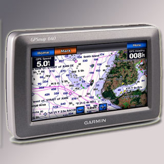
These new devices sport a high-sensitivity GPS receiver and an intuitive, waterproof and super-bright 5.2-inch WVGA touchscreen display that delivers 800 x 480 pixels of resolution.
“Blending the best aspects of our popular portable marine units with the intuitive user interface of our automotive flagship line of nüvi navigators, the GPSMAP 600 series is the perfect tool in the boat and on the road,†said Dan Bartel, Garmin’s vice president of worldwide sales.
In the GPSMAP 640, users will find comprehensive street maps of North America and worldwide shaded relief mapping and detailed US coastal BlueChart g2 charts. Apart from land navigation, the GPS unit also enables users to navigate through sea via marine mount and marine mode. It comes pre-loaded with shaded depth contours, port plans, wrecks and restricted areas in form of charts.
Moreover, the GPSMAP 640 sports optional BlueChart g2 Vision technology with a true 3D ‘mariner’s eye view’ that makes sure of an apt navigation perspective above the waterline, and a ‘fish eye view’ to access an underwater 3D bathymetric contour perspective. The other features include the auto guidance technology the g2 Vision data card, photo references with detailed aerial views of points of interest (POI) such as ports, marinas, waterways and landmarks.
Users can shift between marine and road navigation with ease. Supporting land navigation, the device includes voice-prompted turn-by-turn directions to let users enjoy “Turn right on Main Streetâ€, and an ability to develop custom POIs as well as set up proximity alerts.
Garmin also offers optional GXM 40 antenna, which is sold separately, that works accurately with the GPSMAP 640 to graphically display 20 types of different weather through XM WX Satellite Weather data directly on the screen. Besides road-hunt, users can also get entertained with 200 channels of commercial-free music, news, sports talk and XM Satellite Radio.
The GPSMAP 620 shares similar intuitive interface for easy operations. Additionally, it comes bundled with a worldwide basemap with shaded relief as well as optional street map and marine chart data through an SD card slot. It is specifically designed for international boaters.
While the GPSMAP 640 retails for $1199.99 (approx. Rs. 56,160), the GPSMAP 620 costs $999.99 (approx. Rs. 46,800). The 640 is available in the US market, whereas the 620 is for non-US individuals.


